The OCP Bylaw has been adopted as of January 12, 2026.
The proposed final Official Community Plan Bylaw, No. 1230, 2025 received third reading and adoption at the January 12, 2026 Village Council meeting.
A number of changes were recommended in the staff report accompanying the Bylaw. The staff report can be viewed in part 4 of the agenda package.
You can view the Official Community Plan Bylaw, No. 1230, 2025 and OCP maps at https://cumberland.ca/ocp/.
The OCP Bylaw received first and second reading as of November 10, 2025.
The proposed final Official Community Plan Bylaw, No. 1230, 2025 received first and second reading at the November 10, 2025 Village Council meeting. The maps that form part of the Bylaw are posted separately below.
A public hearing on the OCP Bylaw was held on Monday, December 15 at 5:30 pm, concluding the last step in the public engagement process.
Any proposed amendments to the OCP Bylaw in response to public hearing submissions and to comments from external agencies and First Nations will be presented to Village Council at the time of third and final reading in early 2026.
For a quick overview of what is new in Bylaw No. 1230, view the summary of key changes that was posted in early September, at the same time as the draft OCP. The feedback received during September and October engagement activities is summarized in the Phase 3 Engagement Report. Highlights of revisions made in response to that feedback are captured in the November 10, 2025 staff report to Council.
Draft OCP
The draft OCP has been posted (reflecting Sep. 5 formatting edits).
The draft includes:
- Context
- Vision and goals
- Policies on climate change, natural environment, growth management, housing, heritage conservation, municipal infrastructure, economic development, arts and culture, diversity, equity and inclusion, and recreation and parks.
- Development Permit Areas (incl. Environment, Wildfire, Form and Character, Heritage Conservation)
The supporting maps are posted separately under the tabs below.
The following summaries may help you review the plan:
- Annotated map of proposed changes to land use designations in the Village, affecting land development options (although in some cases rezoning of the property will still be required)
- Summary of key changes in the new OCP
The Village hosted two well attended events, a virtual open house and a drop in open house on September 9 and 10. Open house poster boards have been posted in the Document Library to the right.
You are invited to provide comment online until October 6. Scroll down to "Provide your Feedback" below.
Draft OCP Maps
The tabs above contain the maps that are an integral part of the OCP.
Land Use Maps
Map A: Land Use Designations - This map guides future land use of a property (i.e. commercial, industrial infill residential, multi-unit residential, etc.). Land use designation come into play when properties are redeveloped.
Map B: Active Transportation Network, Parks, Trails and Conservation Areas - This map shows the location of proposed active transportation corridors, new parks and trails, as well as areas desired for conservation.
Map C: Public Facilities, Major Roads, Sewer and Water - This map shows existing and proposed public facilities and large capital infrastructure projects. Generally, these projects are identified in the 2022 background report to Cumberland's development cost charges bylaw.
Map D: Areas Suitable for Sand and Gravel Extraction - This map shows the area suitable for future gravel extraction and generally align with an area intended for future heavy industrial use. Note, Ministry of Mines permits are required for resource extraction.
Map E: Landscape Screening - This map identifies the area at the main entrance to the Village where landscape screening requirements apply. The affected properties have been within a service area since 2017 to pay into a fund that allows the Village to maintain the landscaped buffer along the property frontage.
Development Permit Areas
The following maps outline the areas where development permits are required prior to land alteration, addition to or alteration of a building or other structure. Proposed work within the areas must meet the related Development Permit Area Guidelines (part of the DRAFT OCP).
Map F: DPA 1 - Environmental Protection
Map G: DPA 2 - Groundwater Protection
Map H: DPA 3 - Farmland Protection
Map I: DPA 4 - Wildland Urban Interface
Map J: DPA 5 - Form and Character of Industrial Development
Map K: DPAs 6 - 9 Form and Character of Multi-Unit Residential and Mixed Use, Commercial, Carlisle Lane, and Interchange Lands
Heritage
Map L - Heritage Conservation Area - This map identifies the area where a heritage alteration permit is required prior to the construction, addition to or alteration of a building or other structure. The area corresponds to the downtown commercial core as well as properties on the south side of Penrith Avenue and north side of Derwent Avenue which are designated for future mixed commercial and residential uses.
Map M - Historic Neighbourhoods - This map identifies the historic neighbourhoods in Cumberland for possible future heritage recognition, signage, and to communicate their heritage values.
Project Background
The Cumberland OCP lays out a long-term vision, goals and policies to guide growth and change in the community over 10 years and beyond. The OCP also sets priorities and identifies policies for housing, climate change, economic development, transportation and mobility, infrastructure, heritage protection, arts and culture, food systems, parks and recreation, environmental protection and overall community well-being.
Key OCP goals and policies are implemented through development permit areas and a heritage conservation area which establish guidelines for new, and additions to existing, industrial, multi-unit residential, mixed use, and commercial development in the Village.
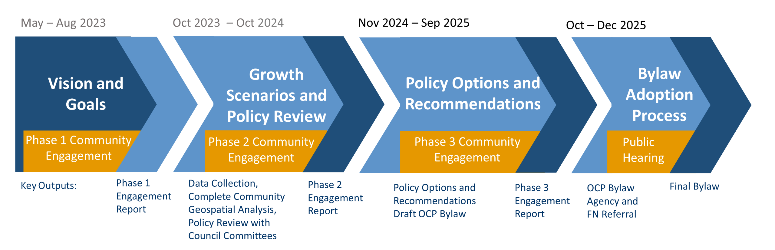
The last opportunity for feedback on the OCP is the upcoming public hearing. The date is set for December 15, 2025. Check the Key Dates section for a link to more information on the public hearing.
The Official Community Plan (OCP) Review was launched with a Plan your Community Street event in May 2023. Over 175 participants shared their long-term vision and goals for the Village and identified hot topics for further discussion (see the Phase 1 Public Engagement Report).
This was followed up with three community meetings in May 2024 and two surveys in June/July 2024 that reviewed land use and growth scenarios as well as policy updates to support the local economy, arts and culture, heritage protection, environmental protection, food security, social inclusion, diversity and equity (see Phase 2 Engagement Report).
The Phase 2 Community Engagement summary report as well as a single proposed land use and growth scenario and recommended OCP updates were presented in the November 4, 2024 staff report to Council.
The Advisory Planning Commission and Village Committees commented on the draft OCP at their meetings in September and October 2025.
In fall 2023 and winter 2024, Village land use planning staff worked with Council committees to review OCP policies connected to the committees' mandates, including accessibility, social inclusion and equity, heritage protection, and housing. In addition, staff and consultants worked with the Advisory Planning Commission (APC) to develop scenarios of where future growth in the Village should go.
The work of the committees and the APC helped shape the the growth scenarios and policy options that were presented for discussion with the community at the May 2024 engagement events (see Policy Review with Council Committees Report)
Between November 2023 and May 2024, consultants hired by the Village to develop a Climate Action Plan completed background research and hosted two public engagement events on goals, reduction target and specific climate actions.
A final Climate Action Plan was approved by Council on June 24, 2024.
Greenhouse gas reduction targets and key climate mitigation and adaptation actions from the Climate Action Plan are included in the OCP.
Visit the Climate Action Plan project page for the final plan and more information.
In fall 2023, the Village received provincial grant funding to assist in a complete community assessment. This included data collection and mapping analysis of housing diversity, transportation options, proximity to daily needs of residential areas and cost of infrastructure servicing in Cumberland. This work informed two land use and growth scenarios presented at the May 2024 OCP community engagement events for feedback. The land use scenarios were refined into a single scenario which informed MAP A: Land Use Designations of the draft OCP bylaw.
A final Complete Communities Assessment Report is available on the Village website.


