The Comox Valley Regional District is creating a Local Area Plan to guide the future of the Saratoga Beach area, a unique and beautiful coastal community. The plan sets long-term direction only. It does not approve development or change zoning, and any future proposals would require separate review and approval.
The plan will support land use and development that respects local ecosystems, addresses climate change, and reflects the values and vision of the community.
Saratoga Beach is known for its rural charm and tourism appeal. It also faces key challenges, including limited water supply in the summer, too much water in the winter, and risks from river and coastal flooding. Its location between the Comox Valley and Campbell River brings both transportation opportunities and pressures.
With public input, the Saratoga Beach Local Area Plan will include a shared community vision, planning goals, and land use directions that reflect what makes Saratoga Beach special.
Your input matters. Share your ideas and help shape a healthy, resilient future for Saratoga Beach.
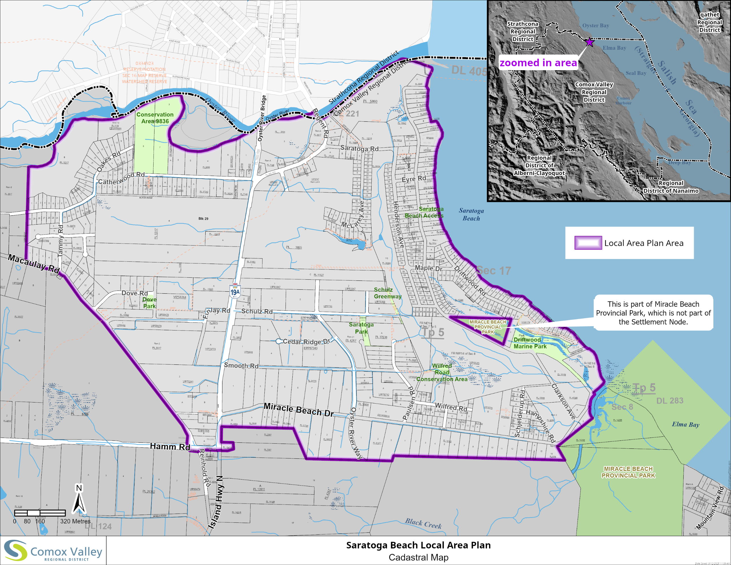
Saratoga Beach Local Area Map
What is a LAP?

A Local Area Plan (LAP) is a detailed land use and development guide for a specific community or area within a municipality or regional district. It tailors policies to local needs while aligning with broader planning frameworks.
Relationship to Other Planning Instruments:
- Regional Growth Strategy (RGS): A long-term plan (minimum 20 years) guiding regional growth in areas such as housing, transportation, and environmental protection. All local plans, including OCPs and LAPs, must align with the RGS. The Comox Valley RGS, adopted in 2011, includes the City of Courtenay, Town of Comox, Village of Cumberland, and the CVRD Electoral Areas (excluding Denman and Hornby Islands).
- Official Community Plan (OCP): A long-term vision for land use and development, guiding decisions on zoning and infrastructure. The CVRD has an OCP for all Electoral Areas A, B, and C (excluding Denman and Hornby Islands), while each municipality has its own. All OCPs must align with the RGS.
- Local Area Plan (LAP): An LAP is developed for specific communities, such as the three Settlement Nodes in the Comox Valley: Mount Washington, Union Bay, and Saratoga Beach. Each LAP addresses unique local characteristics and priorities. (Note: The Mount Washington LAP is Appendix D of the OCP. This is the project page for the Saratoga Beach.)
- Zoning Bylaw: Implements OCP and LAP policies through detailed regulations for land use and building requirements. It governs aspects such as permitted uses (e.g., agricultural, residential, commercial, and industrial), minimum setbacks, and maximum building height.
An LAP translates the broad objectives of the RGS into specific strategies for local development, ensuring alignment with regional goals.
How do We Get Here?
Saratoga Beach is identified as a Settlement Node in the Comox Valley Regional Growth Strategy (RGS) and the Rural Comox Valley Official Community Plan (OCP). It is recognized as a location for planned growth supported by infrastructure, walkability, local services, and housing diversity.
2011 – The Comox Valley RGS was adopted, outlining a regional vision for sustainable growth supported by the CVRD, Courtenay, Comox, and Cumberland.
2014 – The Rural Comox Valley OCP was adopted, providing long-term direction for land use, community character, and environmental protection. The Mount Washington Local Area Plan was also adopted.
2015 – Planning for a Saratoga Beach LAP began in the past but was paused to complete technical studies and meet new provincial requirements, such as a Regional Housing Needs Assessment. Although a draft was prepared, it was never be given any bylaw readings by the CVRD Board. The process is restarting to ensure the plan reflects current data, policies, and community priorities.
2024 – With studies complete, a LAP scope was presented to the CVRD Electoral Areas Services Committee on June 17, 2024. The scope includes assessing infrastructure capacity, environmental risks, natural assets, and alignment with recent housing, planning, and climate legislation.
2025 – The CVRD is launching this project. Public input will be gathered through the project page, CVRD website, surveys, open houses, and focus groups.
What are the 4 Project Phases?
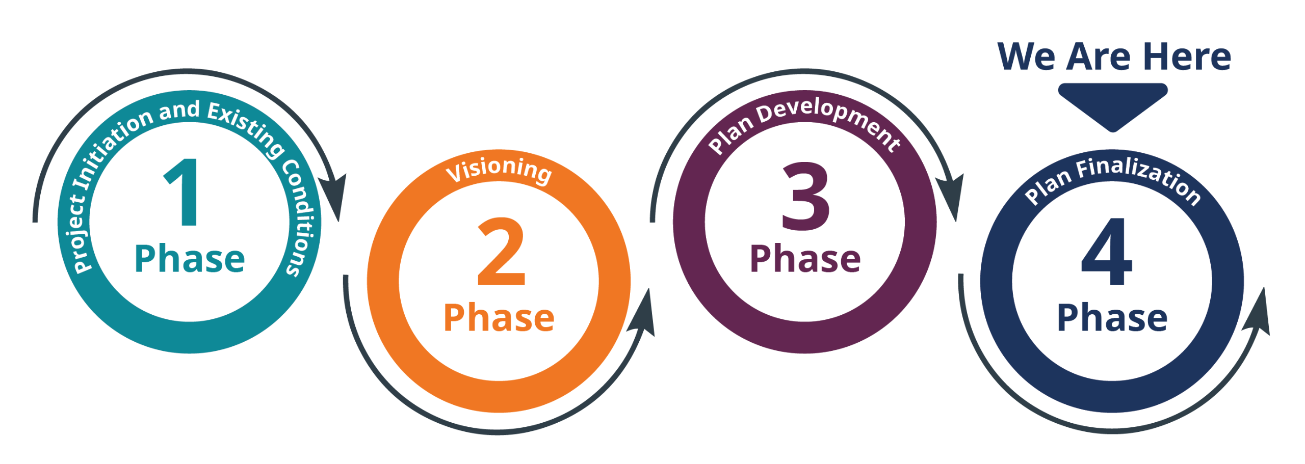
Phase 1 –Project Initiation and Existing Conditions
The consultant begins by working with CVRD staff to confirm the project scope and timelines. Project team members visit the Saratoga area to document current conditions and gather background information. This phase includes developing a strategy to inform and involve the public throughout the project. Community members may learn about the project through the CVRD website, newsletters, or public notices. Local First Nations are also contacted to confirm their level of involvement.
Phase 2 – Visioning
Community members have their first opportunity to participate through a community survey. The survey asks about priorities such as housing, transportation, the environment, and climate change. This feedback helps shape the overall vision for the area. Later in this phase, community members are invited to an open house to review early ideas, including land use concepts and draft policies. Community input helps guide which ideas move forward.
Phase 3 – Plan Development (Current Phase)
Feedback from the open house and survey will guide the preparation of a draft plan. The draft will include updated maps, land use directions, and development policies. A second public engagement opportunity will offer another chance for community members to provide input. The draft plan will be posted online, and CVRD staff will ensure it reflects community values and responds to local needs.
Phase 4 – Plan Finalization
The plan is updated to reflect feedback from community members, rightsholders, and other interested parties. The final version is shared publicly and presented to the CVRD Electoral Area Services Committee. Community members are informed when the plan is ready for consideration by the CVRD Board. Once adopted, the plan will help guide future growth and development in the Saratoga area.
Q&As
The first round of engagement is now complete. We still welcome your questions and feedback. To get in touch, please use the "Who's Listening" section on this page.
To ask a question you must create an account or log in.
These are the people that are listening and responding to your questions.
Brian Chow
Planner
Jodi MacLean
Planner
{{question.description}}


